Miami & Erie Canal, Warren County Canal, and Cincinnati Subway
Miami & Erie Canal, Warren County Canal, and the Cincinnati Subway
Introduction
Studying transportation history is much like studying archaeology.
Multiple layers of strata, whether literal or figurative, must be
peeled back to reveal the history beneath. These layers tell us
about technology, urban development, industrialization, and cultural
priorities as they change over time. In the temporal hierarchy of
transportation, the canal is one of its most ancient systems, preceded
only by primitive dirt trails and cart paths. The earliest canals
were used for irrigation of agricultural fields, but the ancient
Egyptians, Chinese, and Greeks built canals for drinking water and transportation. They provided much improved ability to
move bulk cargo than wagons and pack animals. For this reason,
they became a mainstay of early transportation infrastructure.
It must be understood that even large waterways
like the Ohio River are not naturally navigable at all times of the
year. Dry periods would make the river too shallow for boats to
pass, and floods would make it too dangerous. Even the Mississippi
River doesn’t have enough depth and flow to be naturally navigable
north of St. Louis. On the Ohio River, the falls at Louisville
were only passable by riverboats during periods of high water.
Indeed, these cities are where they are because of the navigational
challenges that required offloading cargo and passengers to different
modes. Commerce thrives at such transfer points.
Nevertheless, there’s great pressure to extend transportation routes
further inland to tap fertile farmland, natural resources, and new
markets. In Louisville’s case, a short canal was constructed in
1825 to bypass the falls and allow boats passage, no matter the river
level. Little was done to improve navigation beyond that until the
late 19th and early 20th century when a series of wicket dams were
built to raise the water level across the entire river, essentially
turning it into a series of shallow lakes.
While the Ohio and the Upper Mississippi River would be further
canalized with larger and more elaborate dams in the middle 20th century to accommodate
ships and barges, navigation was and still is limited to the existing
route of those rivers. In the early 19th century, finding a way to
transport agricultural products across the Appalachian Mountains
to the growing markets of the east coast was critical. No rivers flow across the mountain range, and overland
routes were too slow and expensive for bulk commodities. This is
but one reason many farmers turned to distilling whiskey or other
spirits from their harvested grain, since it had a higher value, less
bulk, and wouldn’t spoil on the month-long journey to New York, Boston,
or Philadelphia. When the Erie canal opened across New York State
in 1825, it linked the Hudson River with Lake Erie, providing a shipping
route from northern Ohio and southern Michigan to the Atlantic
Ocean. Travel times were cut in half, and the tonnage that could
be pulled by a single team of mules or horses increased to such a degree
over pack mules and wagons that costs dropped by a factor of
four.
Construction
The Erie Canal was all well and good for northern Ohio, but there was no
equivalent route to transport grains from the fertile lands of western
and central Ohio to Lake Erie, or southward to the Ohio River for
shipment to the growing cities of Cincinnati, Pittsburgh, Louisville,
New
Orleans, or St. Louis. The Ohio River and Lake Erie watersheds do
not mix, and thus no rivers traverse the whole state north to
south. A man-made waterway was the best option to link the Ohio
River with Lake Erie to create a crisscrossing network of transportation
routes. Developing such transportation links was critical to
supporting the Industrial Revolution, which required raw materials,
fuel, and a means of distributing finished products. This sparked a
wave of canal fever in the early 19th century that saw new routes
developed not just in New York and Ohio, but also Indiana, Illinois,
Pennsylvania, and much of the eastern seaboard. The United
Kingdom, Belgium, the Netherlands, France, and Germany also developed
extensive networks of canals to support growing industries. US
states were anxious to get on this bandwagon.
The Ohio House and Senate had worked for two decades to pass legislation
authorizing a canal, and they finally succeeded on February 4, 1825 after it became evident that the Erie Canal was going to be a huge boon to New York state. This new Ohio canal system would be
largely state-funded. Money was raised by selling bonds, and land
near the canals was sold or leased. Engineer James Geddes, who
worked on the Erie Canal, was hired to design a network for
Ohio. Two waterways would be constructed, the Miami Canal from Dayton to
Cincinnati, and the Ohio & Erie Canal from Portsmouth to Cleveland.
This system would provide the interior of Ohio with new travel routes
that effectively extended to the major Atlantic port of New York City,
as merchants could ship goods through Lake Erie, the Erie Canal, and the
Hudson River to New York.
While the Ohio & Erie Canal was a cross-state venture with multiple
branches, the Miami Canal was originally planned to run only between
Cincinnati and Dayton. The upper reaches of the Great Miami River
watershed would eventually become prime agricultural land, but in the
early 19th century it was sparsely settled and slow growing compared to
the Cincinnati-Dayton corridor. Farther north, the Great Black
Swamp stretched across most of northwest Ohio from Fort Wayne to Toledo,
an even more difficult to traverse and less developed area. So the
focus was on the 66-mile route between Cincinnati and Dayton.
 |
|
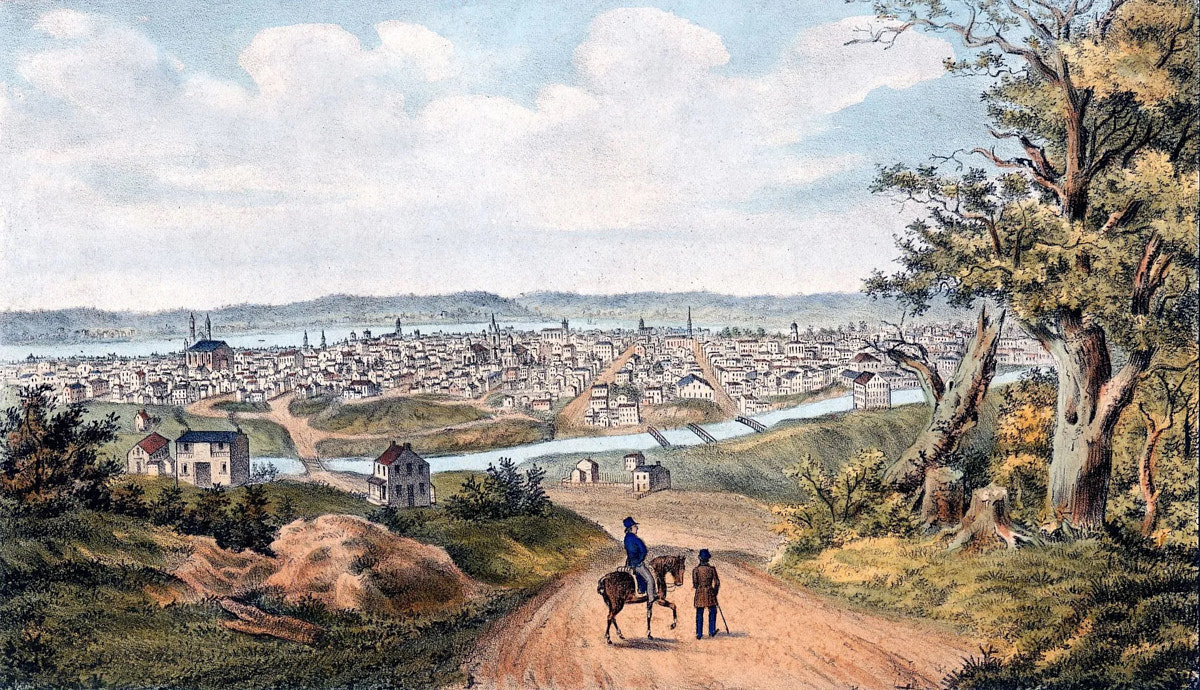
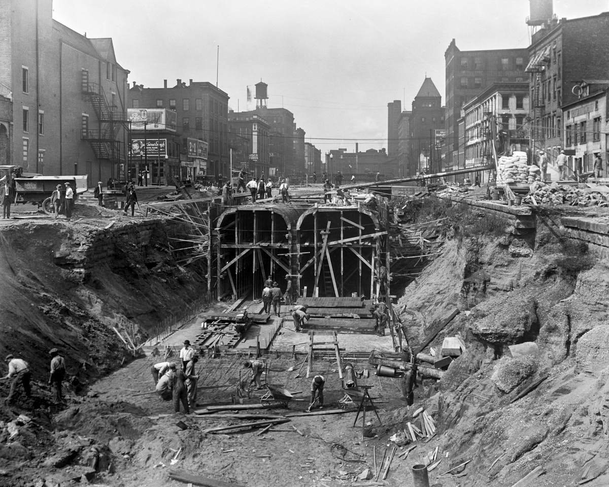
This early
painting of downtown Cincinnati as seen from Mt. Adams in 1841 shows
the Miami & Erie Canal running down what would later become
Eggleston Avenue.
|
At this time in the state’s history there were no construction companies
big enough to carry out such a monumental project as a canal. So
after surveying and land transfers were complete, the state divided the
construction project into numerous sections for local contractors to bid
on. A section could be as small as a single lock, culvert, or aqueduct,
though the typical section length was approximately half a mile.
As sections opened up for bidding, dates of completion were dictated by
the state to ensure speedy construction. A ground breaking
ceremony was held south of
Middletown on July 21, 1825, and the first water flowed into the canal
on July 1, 1827. By August of that year, the canal between
Middletown and Hamilton was open. It was finished to Cincinnati in
December, 1827, but it took four months for enough water to fill the
canal to float any boats to the city. By January 25, 1829, the
full length of the Miami Canal became operational, connecting Dayton to
the Ohio River. It was informally nicknamed the Rhine in downtown
Cincinnati
due to the large number of German immigrants living in the neighborhood
north of the canal. Since many of these residents walked to work
downtown, they were said to be going "over the Rhine" which led to the
neighborhood taking on this name.
On February 22, 1830, the Ohio General Assembly incorporated the Warren
County Canal Company to construct and operate a branch canal to
Lebanon. The seat of Warren County, Lebanon is at the intersection
of the road from Cincinnati to Columbus, and the road from Chillicothe
to Oxford. The city sits on high ground though, so transportation
options were limited, and a branch canal seemed like a good way to
link it to other markets. Work progressed slowly on the canal and
the company eventually acknowledged it could not complete it. On
February 20, 1836, the General Assembly ordered the Canal Commissioners
to take possession of the unfinished project. The Warren County Canal
was made completely navigable in 1840. Built to the same standards as
the Miami & Erie, it began at Middletown at what is today the
Middletown Transit Station at Reynolds Avenue. The lower end of the
canal was supplied by a feeder
off the Miami & Erie Canal three miles north at lock #30 (Lower
Greenland).
From Middletown, this canal went southeast over land filled with sand
and gravel deposited by the Wisconsinan Glaciation 14,000 to 24,000
years ago. This geology meant the canal leaked considerably.
Two aqueducts carried the canal over Dick's Creek, but the aqueducts
were built too shallow for use by heavily laden canal boats. The
canal continued its path southeast into Turtlecreek and Union townships
along the path of Muddy Creek to about Hageman Junction at US-42.
There it turned northeast, paralleling Turtle Creek, which it crossed
on an aqueduct, approximately the route later taken by the Cincinnati,
Lebanon & Northern Railway. At Lebanon, there was a turning basin in
the space bounded by Sycamore Street, South Street, Turtle Creek, and
Cincinnati Avenue. The canal was fed with water from the North and East
Forks of Turtle Creek at Lebanon.
Lebanon is 44 feet above the elevation of the Miami & Erie Canal at
Middletown, so six locks, each 90 feet long and 15 feet wide, were
necessary to overcome this. Lock #1 was at the foot of Clay Street in
Lebanon. Lock #2 was a short distance downstream, still in Lebanon. Lock
#3
was about a mile southwest of Lebanon near Glosser Road and Turtle
Creek. Lock #4 was about three miles southwest of Lebanon near the
confluence
of Muddy Creek and Turtle Creek. These locks raised and lowered boats a
total of 28 feet. Locks #5 and #6 were just east of where
the canal entered the Miami & Erie in Middletown, they were most
likely on the hill between Curtis and Garfield, and they raised and
lowered boats the remaining 16 feet.
Not long after the Miami Canal opened, the Wabash Canal in Indiana began
construction in 1832. It would run between Evansville and Toledo
via Terre Haute, Worthington, Lafayette, and Fort Wayne. It
reached Lake Erie by following the Maumee River through the Great Black
Swamp. After political lobbying, Ohio agreed in 1831 to build the
Miami Extension Canal, which would run from Dayton to the Wabash &
Erie Canal just south of Defiance (Junction), creating a through route
to Lake Erie. Work on the extension started in the spring of 1833
and it was completed as far north as Piqua by June 20, 1837. The
first canal boat was launched the next day, and it reached Piqua on July
5 after a one-day delay because of a lack of water north of Troy.
Piqua served as the northern terminus of the extension until 1842 when
additional sections to the north started opening. By June 1845,
the entire Miami Extension Canal was finished, and travel from
Cincinnati to Toledo became possible. Of the 250 mile length of
the finished canal, only four miles were in slackwater, which were
dammed segments of the Maumee River. In 1849, the Miami Canal,
Miami Extension Canal, and Wabash & Erie Canal north of Junction
were merged and renamed the Miami & Erie Canal.
Cincinnati was also served by a second canal running to the fertile
farmlands of southeast Indiana. Ground was broken for the
Whitewater Canal on September 13, 1836, on a route between Lawrenceburg
and Hagerstown. In 1838 the Cincinnati & Whitewater Canal
broke ground to connect Cincinnati to the Whitewater Canal at
Harrison. This second canal opened for business on November 28,
1843, and the main canal finished construction in 1847. Though
built for a similar purpose as the Miami & Erie, the two canals did
not have a connection to one another, since the Cincinnati &
Whitewater Canal terminated at Pearl Street (today between Pete Rose Way
and 3rd Street) and Central Avenue near the riverfront at a much lower
elevation than the Miami & Erie, and it had no direct connection to the
Ohio River. More information can be found in the history of the
New York Central/Big Four Railroad's CIND and Whitewater divisions.
How The Canal Works
While a canal may look like a small river or creek, it is actually more
like a series of long narrow lakes. There is water flow, but the goal is
to create a pool with a consistent depth and width that has minimal
current. Excess flow would cause undesirable drag on boats,
erosion of the banks, and it would deposit sediment where the current
slackens. Also, a level water surface and canal bottom is
necessary to maintain the tight depth clearance needed. The
overall shape of the canal channel and earthen berms is called the canal prism. Dimensions were 40 feet wide at the water line,
approximately 28 feet at the base, and the depth would be at least four
feet to allow a maximum draft of three and a half feet for canal
boats. North of Dayton to Junction the width at the water line was
50 feet, and from Junction to Toledo it was 60 feet. Why exactly
the canal used a wider prism farther north is unclear.
Since building a canal below existing grade would subject it to flooding
and sediment from rains and nearby rivers and creeks, they were
generally built so
the bottom of the canal was near existing grade, and the berms on either
side would act as dikes or levees to hold in the water. This way,
any perpendicular streams or rivers could flow underneath through a
culvert pipe or aqueduct. One of the berms would have a towpath,
which was specified to be 10 feet wide. It was to allow horses,
mules, and their handlers to pull the canal boat with a long rope.
The towpath was most often on the lower side of the underlying terrain,
and thus when paralleling a river, on the river side. The extra width
of the berm provided more resistance to the weight of the water
behind it.
The opposite berm bank, or heelpath, was only six feet wide. The
top of the towpath and heelpath were six feet from the base of the
canal, allowing two feet of extra height to accommodate overflow and
splashing. Occasionally the towpath or heelpath
would dip down to allow excess water to overflow out the side in a
controlled manner where the embankment was reinforced to resist
erosion. At several points along the canal there were more
elaborate spillways to discharge excess water.
 |
|
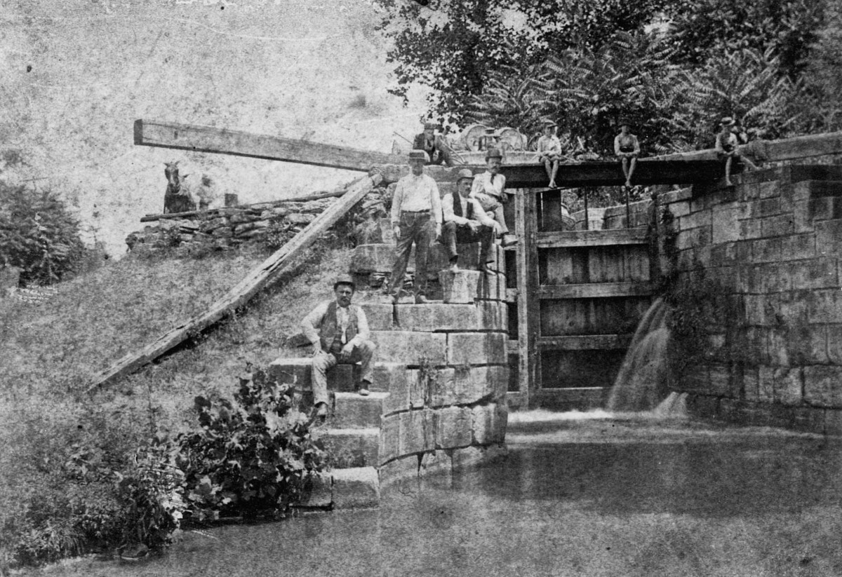
The Excello lock was the first
constructed on the Miami & Erie Canal. Note the large stone
blocks and the wooden gate holding back the water.
|
Before laborers could even begin to build the canal prism they first had
to remove any stumps, roots, rocks, and topsoil. This process was known
as grubbing. Although labor intensive, grubbing was necessary for the
integrity of the canal prism. Leftover roots could sprout through the berm bank or towpath, creating breaks in the
prism. In areas where the soil was particularly porous, the bed of
the channel was lined with puddle, a mixture of clay and water
intended to slow or stop water from percolating into the ground. Puddle
was also used as a bed for foundation timbers, which were an integral
component to stone canal structures. The Warren County Canal
either didn’t use puddle or it wasn’t thick enough to prevent
significant exfiltration.
While a single long narrow lake would be the simplest to navigate, it is
not the simplest to build. Because land is almost never entirely
flat, a system of locks had to be built so the canal wouldn’t need
numerous deep cuts, tunnels, or elevated aqueducts. A canal would
be of little use in a tunnel hundreds of feet underground or on a high
aqueduct with no easy way to reach it to load and unload cargo.
At Spencerville, between Delphos and St. Marys, a deep cut of up to 52
feet was still necessary to breach a one and a quarter mile ridge and avoid the need
for a tunnel or several locks. Even if the land was as flat
as possible, the Ohio River at Cincinnati is roughly 100 feet lower than
Lake Erie, so a perfectly flat connection between the two bodies of
water is not possible. Also, the Loramie Summit is a 20 mile
plateau between Lockington, north of Piqua, and New Bremen, which is 395
feet above the level of Lake Erie, and 510 feet above the Ohio
River. The canal would need to climb over this ridge.
To move vertically, 107 locks were built along the length
of the Miami & Erie Canal, with 54 climbing from Toledo to the
Loramie Summit, and 53 descending to the Ohio River. A lock
(specifically a pound lock) is a chamber made of stone or wood with the
ability to raise or lower a boat to a different elevation. In the
case of the Miami & Erie, they were built 15 feet wide by 90 feet
long with tall retaining walls on each side. There were wooden gates at the ends that when closed formed a
“V” shape pointed upstream which used the the weight of the water above to hold the
gate closed. A canal boat would approach a lock and then call the
attention of the lock tender. The tender would assist with tie
ropes and operating the gates, as well as collecting tolls. If the
first gate was closed, they’d have to wait for the lock to be drained
or filled before proceeding. Otherwise, the boat would enter the
lock, and the gate it passed through would be closed. Operating a
gate could only be done when the water level was completely equal on
both sides, at which point the gate could be moved with a long pivot arm
extending over the bank. After the gate was closed and the boat
secured in place, a sluice gate (often referred to as a paddle) either
in the lock gate itself or underground, would be opened via a crank to
allow water to flow in or out depending on whether the boat was going up
or down. When the water reached the new level, the exit gate would be
opened and the boat could proceed. This whole process took about
10 minutes.
Using a lock drained a significant amount of water out of the upstream
length of the canal, so there were often wider pools to create extra
water volume and also give canal boats a place to wait if there was a
boat coming in the opposite direction. When the locks were closed,
water from above would either spill over the gates, or in the case of
the Miami & Erie Canal, a bypass channel was built on the heelpath
side so excess water could flow around the lock and then over a spillway
to the lower section of canal. All of the locks were built of cut
stone with wooden floors, although the 36 locks north of the Loramie
Summit to Defiance were built of wood. Some of those wooden locks were replaced with
poured concrete at a later date. Other locks, called guard locks,
were simply water control structures where water was fed from natural
streams into the canal. They could be opened, closed, or adjusted
to prevent excess water from entering the canal during floods, or to
increase water flow during dry times.
All this water had to come from somewhere, so natural and man-made
lakes,
reservoirs, and rivers were used to provide a constant supply of
water. One of the more challenging problems was supplying water to
the Loramie Summit, since no sizable lakes or rivers exist nearby at
that elevation. The Loramie Reservoir (Lake Loramie) was built in
1844-1845 to supply water to the summit, but this proved to be
inadequate, presumably because the flight of six locks at Lockington
drained a lot of water out of this section of canal. To remedy
this, an existing lake fed by small creeks and springs in Logan County
between Wapakoneta and Bellfontaine was was greatly enlarged in 1851 to
become the Lewistown Reservoir (Indian Lake). It provided a
consistent flow of water into the Great Miami River. Downstream, a
dam was built just east of Port Jefferson to divert water into the
Sidney Feeder Canal, which paralleled the west bank of the river through
Sidney to Lockington. The Sidney Feeder was also navigable and it
functioned as a branch line. The Mercer County Reservoir (Grand
Lake St. Marys) was constructed between St. Marys and Celina in 1837 to
provide water to the canal north of the Loramie Summit. Although
fairly shallow, it was the largest man-made lake in the world when it
was
built. A 2.5 mile navigable feeder connected the east bank of the
lake with the canal, and it allowed boats to traverse the lake to reach
Celina.
Beyond the summit, water could be fed by larger rivers such as the
Maumee, Auglaize, Mad, and Great Miami. At the lower end of the
canal in Butler and Hamilton counties, numerous small creeks in
Fairfield and West Chester were fed directly into the canal, as well as
some small spring-fed streams around Clifton in Cincinnati.
However, the only significant source of water to this lower 43 miles of
the canal came from the Great Miami River north of
Middletown where a large dam was constructed. This may explain why it took so long for the
water to reach downtown Cincinnati after the canal opened.
Although the canal paralleled Mill Creek for nearly its entire length,
it does not appear that the creek was ever used as a water source for
the canal, only as a means of draining overflow.
Early Operations
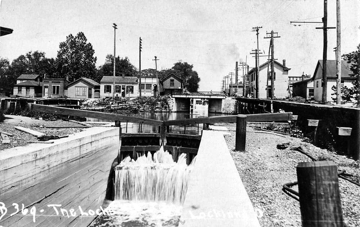 |
|
One of the four locks in Lockland that provided not only transportation but also water power to neighboring mills and factories.
|
After the canal became operational, villages and cities sprang
up along
its length to take advantage of the new transportation abilities.
Though primarily a freight-hauling operation, passenger transport was
popular as well for the first few decades. The canal also
became a valuable water power resource for mills and factories.
The state charged low rates for use of canal water as a way to encourage
industrial growth that would bring canal shipping and tolls. In
Cincinnati, the numerous breweries along the canal not only used it to
haul in their brewing feedstock and to distribute finished product,
they also made extensive use of canal water for cooling.
The potential energy of canal water is multiplied when there are
several locks in short succession, which was the case at Lockland. There were
three locks in a row between Wyoming Avenue and Patterson Street (Upper Lockland #40, Collector's #41, and Flour Mill #42). A
fourth one was located just a quarter mile downstream (Allen & James Service [?] #43). This attracted
numerous factories, and they built a complicated network of feed
channels, raceways, and basins to divert the water to their mills and
provide loading and unloading areas for canal boats. The most
notable was the Stearns & Foster Company, which was founded in 1846
to make cotton goods and upholstery for horse-drawn carriages,
eventually becoming a sizable mattress manufacturer. There were
other woolen mills, paper mills, blacksmiths, box factories, roofing manufacturers, and starch
processors in Lockland. Paper and grist mills set up at other
locks to the north of the city in Rialto and Crescentville to take
advantage of the water power. The cities of Hamilton, Middletown,
Franklin, Miamisburg, Tipp City, Troy, and Piqua all started as canal
mill towns with easy access to markets and adjacent productive
agricultural land. Lockington never developed much industry
however, perhaps due to the limited water availability at the summit,
but it did host a sawmill, grist mill, and grain silo. Purportedly
there were at least six saloons and a brothel in this small hamlet, set
up for weary travelers and canal boat crews awaiting the sometimes
hours-long trip through all six locks.
The goings were not always great however. Canal boats, often
family-owned where everyone lived onboard, would have to cease
operations in winter when the canal froze over. To take some
advantage of this limitation, numerous ice ponds were built adjacent to
the canal. They would fill their basins with canal water, and ice
would be harvested and stored in nearby ice houses until the
spring. When the canal thawed, ice would be sent to the cities via
canal boat. Even when freezing temperatures were not an issue,
problems with water flow or washouts caused by heavy rainstorms could
sever the connection between various sections of the waterway.
This made canals highly vulnerable to railroads that began opening up
even before construction was completed.
First Signs of Trouble
The canal was profitable at first, but revenues started to decline as
early as 1852. Railroads were opening throughout the state
in the 1840s, and they expanded rapidly in the 1850s. They had the
advantage of much quicker travel, especially important for passengers,
the ability to haul much more bulk in a single train, and they weren’t
strangled by freezing temperatures or a lack of rainfall. By the
1860s, the canal was only economically viable for shipping bulk
agricultural products, building materials, and other non-perishable
goods. Additionally, the sparse population and lack of industrial
development north of Dayton further limited the canal’s success.
Though the Great Black Swamp was gradually drained and it became highly
productive agricultural land, it still remained sparsely settled and
difficult to travel through during the canal era. It wasn't until
railroads were built through that area that development started to take
off.
The Warren County Canal was also having problems at this time. Due
to the persistent leaking of the canal, Shaker Creek was diverted into
it to provide extra water. This stream drained the large
swamp on the Shaker settlement at Union Village. It frequently
jumped its banks and flooded the canal, depositing sediment that
required constant dredging and repairs. Finally, Shaker Creek broke
through the canal's embankment in 1848. In 1852, John W. Erwin,
the resident engineer of the Miami & Erie Canal, investigated
repairs to the canal by direction of the General Assembly. Because
the canal had been little used, the State declined to repair it. In the
General Assembly, Representative Durbin Ward of Lebanon introduced
legislation to abandon the "Lebanon Ditch." In 1854, the state sold the
remnants for $40,000 to John W. Corwin and R.H. Henderson. The
large stones from the locks were sold off and used in local buildings
and bridges. The Whitewater Canal also suffered several disastrous
floods in 1847 and 1852, and it was finally abandoned in 1856 along
with the Cincinnati & Whitewater Canal. Parts of the
Whitewater Canal were retained for hydraulic water power use, but
railroads were quickly built over the towpaths and canal beds.
In 1861, the canal system was leased to a private operator for an annual
fee of $20,000 over a ten-year period. The operator soon discovered
that the canal in Cincinnati between the Lockport Basin at Sycamore
Street and its endpoint at the Ohio River was a liability. The
flight of ten locks, at which there was purportedly a toll collector at every single
one, was both too expensive and took too long to navigate. Since
Cincinnati itself had become a major market for the goods floating down
the canal, trans-loading canal barges to riverboats was less
necessary. Even for goods that did need to go to the river, it was
still cheaper to offload to wagons at the Lockport Basin for hauling to
the riverfront. Thus, in 1863 this last mile of the canal
was abandoned. The State of Ohio granted the city use of the canal
right-of-way to build a road, and the city spent a large sum of money
burying the old locks, grading Eggleston Avenue, and building a sewer to
maintain water flow from the end of the canal to the river. The
city then granted the Little Miami Railroad permission to build a track
up Eggleston that would eventually connect it with the Cincinnati,
Lebanon & Northern Railway terminal at Court Street. The Ohio
Supreme Court determined that this violated the agreement the state made
with the city, and Eggleston was forfeited back to the state.
This was advantageous for the railroad, since not long after this time
the city tried to eliminate railroads from city streets because they
blocked pedestrians and vehicles. Since the state owned the
street, the city had no authority to block railroad operations.
Decline & Failure
In 1871, the state renewed the lease with the investment company, but
declining revenues led to them relinquishing control in 1877, and the
state Board of Public Works resumed operations. The Miami &
Erie Canal Association was established in 1878 with the aim of
revitalizing the canal. They advocated for the construction of new canal
boats and improvements in the canal’s infrastructure, including larger
locks. Some of these upgrades were gradually implemented between 1904
and 1911. The association also backed the Miami & Erie
Transportation Company’s endeavor to lay tracks and utilize an electric mule to tow canal boats. This would replace animals
with an electrified railroad powered by overhead wiring similar to a
streetcar or electric interurban railway.
Plans for the mule to
run the full length of the canal were scaled back to just Cincinnati to
Dayton, and then scaled back again to Cincinnati to Hamilton.
Standard gauge tracks were laid on the towpath, and the electric mule
was put in service in approximately 1902 after an expenditure of roughly
$2 million. Steeple-cab three-phase locomotives were used to pull
the barges, but problems soon became apparent. At speeds any
greater than the three to four miles an hour usually achieved by horses
and non-electric mules, the boats would create so much wake that it
would wash out the canal bank. Faster speeds would also cause
boats to drag their keel on the bottom of the canal. The inertia
of a fully-laden canal boat was even enough derail the locomotive when
stopping abruptly. By 1905 the mule project was shut down and
scrapped.
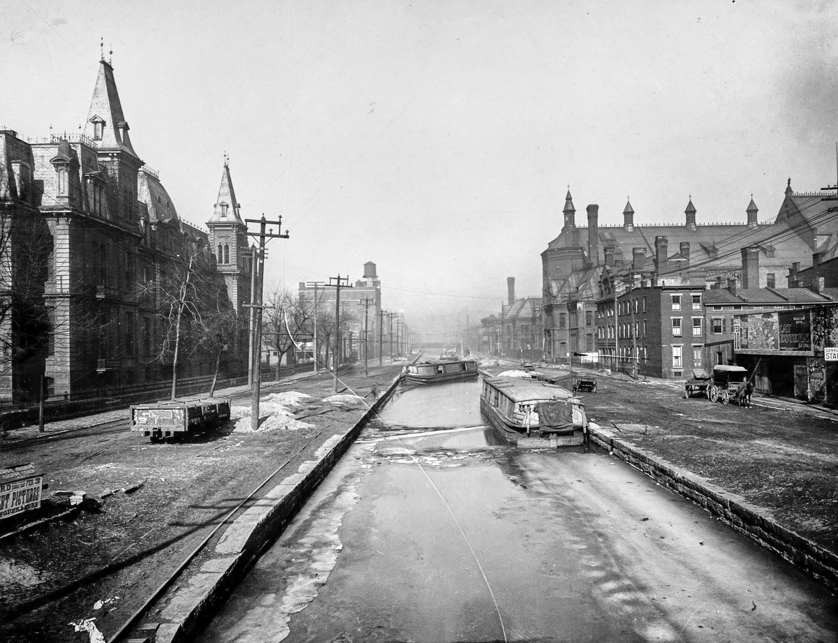 |
|
Canal boats near Music Hall in
Over-the-Rhine are frozen in place and may be abandoned as the canal
falls out of use. The electric mule tracks on the towpath to the
left are already disused as well.
|
The work of the Association to upgrade the canal failed to
attract new
business and it fell into disuse. The last canal boat ran to
Sidney up the feeder canal in 1904 or 1905. The last boat on the
main canal in west central Ohio was piloted by Captain Billy Coombs. He
made the final run from a gravel pit outside of Newport to Ft. Loramie
in 1912. A canal boat operated by Captain Harry Newton crashed
into the aqueduct carrying the canal over Loramie Creek that same year,
severely damaging it. State officials refused to repair it. After this
time, canal boats were abandoned where they sat, often becoming derelict
platforms for neighborhood boys to fish from.
Though the canal was falling out of use for transportation, its value as
a source of water for industrial use remained. As the Cincinnati
neighborhoods and cities in the Mill Creek Valley industrialized in the
late 19th and early 20th centuries, the canal became a reliable source
of clean water that was used for various industrial processes then
dumped into Mill Creek. While an account of the Mill Creek in 1878
described it as clear with a pebbly bottom, by the first decade of the
20th century it had become a putrid mess of industrial and human waste
and it was one of the most polluted streams in the whole country.
Paper mills discharged spent bleach and hydrochloric acid, cotton mills
discharged caustic soda, and roofing manufacturers fouled
the water with asphalt and coal tar wastes. In 1910 the Ohio Board
of Health urged the state Board of Public Works to divert the canal’s
entire Sunday flow into the Mill Creek at Lockland to flush away the
industrial pollutants and sewage. The sizable overflow spillway
opposite Spring Grove Cemetery, as well as increasingly leaky aqueducts
in Carthage and at Mitchell Avenue, added much needed volume of clean
water to Mill Creek. Of the roughly 84 million gallons of water
brought into the Mill Creek Valley by the canal, only 48 million gallons
were discharged into the Ohio River. The remaining 36 million
gallons found its way into Mill Creek through various spillways, mill
races, percolation, aqueduct leaks, and factories. This increased
flow in the Mill Creek by some 35%.
The canal south of Dayton, which ran parallel to the Great Miami River,
was heavily damaged by the Great Dayton Flood of March 1913. After
a winter of record snowfall, heavy spring rains caused a massive flash
flood which inundated the Great Miami River Valley. This not only
destroyed every bridge over the river between Dayton and the Ohio
River, it also flooded the canal, destroyed aqueducts, washed out
banks, and damaged locks and culverts. The multi-span aqueduct
over the Mad River in Dayton was destroyed and it was never
replaced. The remaining segments of the canal elsewhere were
neglected and gradually deteriorated. This same storm damaged the
Ohio & Erie Canal, the southern portion of which was already
abandoned by 1911, and it wasn’t repaired either.
As more and more water was diverted out of the canal and into Mill
Creek, and as the canal further fell out of use, it became something of a
point of embarrassment to the city of Cincinnati. Since it ran
through the most urbanized part of the city, it became a dumping ground
for garbage and debris. Lackluster water flow would cause
stagnation and odor that was perceived as a public health threat, even
though the miasma theory of bad air causing diseases had been superseded
by germ theory in the late 1800s. The canal was rather unfairly
maligned in this respect, but it was used as a rallying cry to replace
the canal through the central city with a more modern transportation
system.
The Cincinnati Subway
In the first decade of the 20th century, proposals were being floated
for a new union station for the city’s railroads. Individual stations were scattered around the periphery
of downtown, which made connecting trips and freight interchange
excessively difficult. Several electric interurban railways
opened at this time as well, linking the city and rural communities with cheaper
and more frequent service than the steam railroads. However, they
either terminated near the edge of the city limits, or they had to run
lengthy and slow routes over the street railway system to reach
downtown. A solution was needed for both situations. The
railroad terminal studies, as well as the interurban connection
proposals, largely ignored the canal as a potential route.
Proponents feared that any rail proposal utilizing the canal would
invite public backlash due to the situation at Eggleston Avenue.
Since that section of the canal closed in 1863, it became a tangle of
railroad tracks with numerous sidings and spurs into the adjoining
factories and warehouses. Travel was excessively difficult through
that area due to trains frequently blocking the street. The
Gilbert Avenue Viaduct was built specifically to bridge this mess.
There was a real fear that this could happen along the whole rest of
the canal bed if it was converted to rail use. However, a
Parisian-style boulevard with a subway underneath was a more palatable
image for the city looking to improve its dirty industrial image.
The state agreed in 1911 to lease the canal lands to Cincinnati,
including for use as a subway, though restrictions on steam trains were
written into the agreement, limiting it as a freight or long-distance
passenger train system in favor of electrified rapid transit. The
lease itself was signed in 1912, and the city formed the Interurban
Rapid Transit Commission to begin planning.
 |
|
Construction of the subway in the
canal bed. Note the lack of any underground utilities.
Digging was nearly as simple as if in a cornfield.
|
While the steam railroads looked to a riverfront or West End
location, and they eventually settled on the West End site that would
later become Union Terminal, Bion J. Arnold, the country’s preeminent
electric railroad
consultant, was hired by private business firms to develop a plan for an
interurban terminal system. He proposed a downtown loop under
Plum,
4th, and Sycamore, while the primary terminal and connection to the rest
of the rapid transit route would be under the newly-constructed Central
Parkway in the old
canal bed. The canal was a perfect place for a subway because few
or no utilities ran underneath it, making the excavation simple and
inexpensive. A much larger loop would follow the canal north to
St. Bernard where it would veer east through Norwood to Oakley, Hyde
Park, and O’Bryonville before following the slopes of the north bank of
the Ohio River to a tunnel under Mt. Adams and back to downtown.
The broad gauge interurbans that operated over the street railway would
be converted to standard gauge, since dual-gauge trackage in the subway
would increase cost and operational complexity. Of the nine interurban
lines serving Cincinnati, four were within easy reach of the proposed
loop, these were the Ohio Electric (precursor to the Cincinnati &
Lake Erie), the Cincinnati & Hamilton (Mill Creek Valley Line), the
Interurban Railway & Terminal's Rapid Railway division, and the
Cincinnati & Columbus. Due to the north and easterly route of the
loop, the Cincinnati, Lawrenceburg & Aurora was pretty much out of
luck, operating along the Ohio River to the west. The Cincinnati,
Milford & Blanchester planned to build an extension from their
terminus at Erie Avenue near Red Bank to the loop in Oakley via
Brotherton Road. The two IR&T divisions and the Cincinnati,
Georgetown & Portsmouth which operated to the east and terminated in
Columbia-Tusculum also were far removed from the loop. A proposed
concrete or steel viaduct to connect them to the loop near Torrence
Parkway was far too expensive for either company to handle, and they
were basically out of luck as well.
Since the Arnold report envisioned the loop to be entirely for
collecting interurbans that had no hope of supporting such an ambitious
project, in 1914 the city funded the Edwards-Baldwin Report. This
analysis eliminated some of the more extravagant connections to
far-flung interurban tracks and focused more on the logistics of an
urban rapid transit system. This report modeled the system on
Boston’s Cambridge-Dorchester subway (today’s red line) which could
achieve speeds of 45mph with grades up to 2%. This was first and
foremost a rapid transit system that could also operate mixed with
interurban trains. Thus, exclusive rapid transit vehicles and/or
electric streetcars would provide a backbone of service through the
system. As in cities like New York, Boston, and Chicago, it was
hoped that easier transportation to outer neighborhoods would allow
people to move out of overcrowded tenement buildings. The density
of Cincinnati’s Over-the-Rhine and West End neighborhoods was surpassed
only by New York, so there was pressure to provide transportation to
other parts of the city. The overall loop route from the Arnold Report
was retained, but Edwards-Baldwin made tweaks to alignments, surface
versus buried construction, and specific station locations.
The plan for the downtown loop was a variable that saw several proposed
options. One was similar to Arnold’s, another eliminated the
downtown loop by running the main loop under 9th Street and not
utilizing the canal until Plum, and a third kept the downtown loop but
eliminated the Mt. Adams tunnel for a more circuitous routing around the
hillside to Pearl Street. Even with such extravagancies as the
Mt. Adams tunnel and Columbia Avenue viaduct, the cost per mile was the
lowest of any subway project in the United States at the
time.
City voters overwhelmingly approved the issuance of $6 million worth of
bonds to finance construction in 1916. The city then immediately
started negotiations with the Cincinnati Street Railway to operate
it. Although the city had the authority to run the subway, this
was an opportunity to renegotiate the city’s franchise agreement with
the street railway company and to offload some of the cost of outfitting
the system to them. The street railway would purchase the cars
and all the electrical delivery components of the system, including
building a power plant. This would amount to roughly $2 million
above and beyond the cost of the infrastructure being handled by the
city. There was much contention between the interurbans and the
city over this agreement. Many of the interurbans that were built
to broad gauge so they could operate on the street railway were squeezed
out by incredibly expensive lease terms and restrictions, and they
feared the same fate in the subway with the Cincinnati Street Railway
running it.
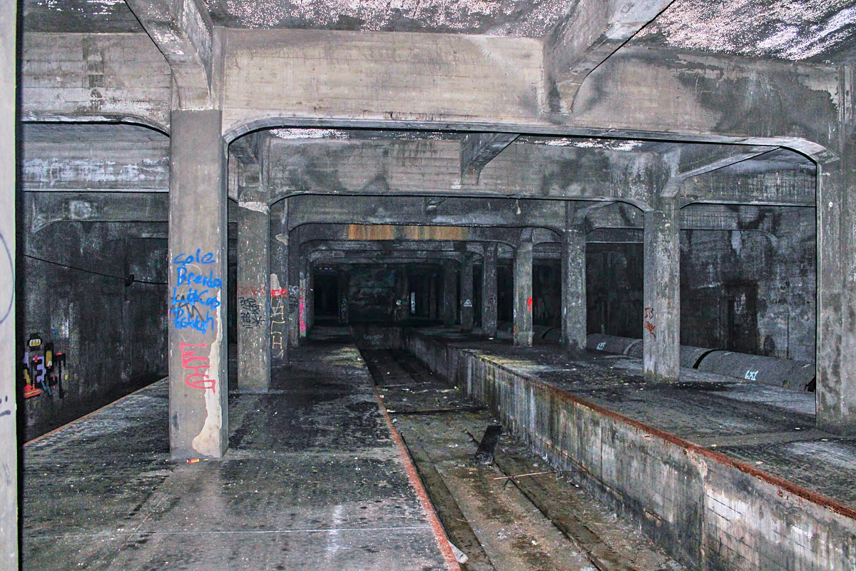 |
|
What remains of the Race Street
subway station today. The through tracks are on either side, and
this stub-end track in the middle was for terminating interurban cars.
|
Unfortunately, just as the lease terms and operating agreements were
being formalized, the United States entered World War I. This was the
downfall of the project, since significant inflation left the bonds far
short of sufficient to build the proposed loop. Ratification of
the 18th Amendment and the start of Prohibition in 1919 also put a lot
of Cincinnati’s residents who worked in its breweries out of the job.
The reduction in tax revenues put further strain on building programs
like the subway. Two big changes were made to the loop proposal in
light of the reduced purchasing power of the bond money: both loops
were eliminated. The downtown loop, which was not part of the
canal and would require relocating numerous underground utilities, was
scrapped in favor of a terminal at Central Parkway. Also, only the
west leg of the overall loop would be built from downtown to St.
Bernard and east to a new proposed terminal in Oakley. The rest of
the loop coming back towards downtown through Hyde Park, O’Bryonville,
and Mt. Adams would be a later phase of the project.
After the lower end of the canal was abandoned for construction of the
subway, the entirety of the canal’s water was diverted over the Spring
Grove spillway on July 1, 1919, greatly improving water quality in the
most polluted lower part of Mill Creek. Not long after that,
subway construction began in the drained canal bed in 1920. Much
like the canal before it, sections were put out for bid by various
construction companies. All told, eight sections were built from
Walnut Street along Central Parkway and I-75 to the Norwood Lateral
Highway and Waterworks Park, though the final ninth section in
Oakley was never started. Money ran out before tracks, rolling stock,
or station fittings could be purchased, and by the time construction
ended in 1925, most of the interurbans were already out of business as
well.
At this same time, the old George “Boss” Cox political machine that had
been running city politics since the 1880s faced funding shortfalls
after decades of grifting and patronage. Murray Seasongood and the
Charterite party took control after extensive anti-corruption
campaigning. Seasongood then quickly removed appointees from the
prior administration, including those of the Rapid Transit
Commission. In 1927 he authorized the Beeler Report to study what
to do with the subway that had all tunnels, grading, and station
buildings completed to Norwood, though lacking any tracks, rolling
stock, electrical systems, or station appointments (they were basically
concrete shells). This report suggested some outlandish items like not
using the Liberty Street Station, demolishing others, and relocating
some of the right-of-way. This report seemed designed specifically
to sow confusion and consternation among the populace so they wouldn’t
support any further bond issues for completing the project.
A second and much more reasonable report in 1929 by Beeler proposed
using the extant subway from Northside to downtown for streetcars and
the Cincinnati & Lake Erie interurban. It nearly came to
fruition if not for the Great Depression. Also, the most difficult
and expensive section of the subway under Walnut Street to Fountain
Square and back would require several years of construction and
disruption to the city’s streets. This would overlap an election
season and potentially threaten Seasongood’s newly-held position of
power. So the subway was quietly let go as a failed project of the
previous administration. Cincinnati Mayor John Cranley would
attempt to kill the current downtown and Over-the-Rhine streetcar loop
in 2013 in a similar manner, though he was narrowly outvoted by the city
council. While the tunnels under Central Parkway remain to this day,
maintained in good condition, and still suitable for future light or
heavy rail plans, the critical and most difficult section of subway
under Walnut Street was never built. Most of the surface right-of-way
was obliterated by the construction of I-75 and the Norwood Lateral,
with only short unnoticeable stretches remaining. Some of the other
tunnels are still in place, but filled in or sealed up.
The End
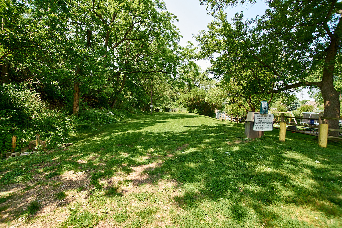
 |
|
A typical view of the remains of
the Miami & Erie Canal in rural areas. A drained channel that
is often overgrown and forgotten, but obvious to those who know what to
look for.
|
Just as the subway project fell dormant, a formal closing ceremony was
held for the Miami & Erie Canal in Middletown on November 2, 1929,
at the same site where ground was broken over a century earlier.
The water between Dayton and Cincinnati was shut off so highways could
be built on the canal right-of-way. Due to construction of the
subway, the transfer of water from the canal to Mill Creek had moved
upstream to Lockland in 1925 before being shut off entirely. With
the loss of the canal’s water, Mill Creek’s pollution problems would
become ever worse until interceptor sewers, treatment plants, and
environmental monitoring and regulation started to reverse the
tide. It still has a long way to go however.
Although Cincinnati’s subway never came to fruition, Central Parkway
did. Erie Boulevard in Hamilton, Verity Parkway in Middletown,
Riley Boulevard in Franklin, and Patterson Boulevard in Dayton are
similar roads built over the canal. The development around these
urban highways took on an automobile-centric pattern of parking lots,
service stations, large setbacks, and empty space. Such a built
environment is anathema to the transit-oriented development that would
have come with a subway, and the canal-era development that preceded it
has been whittled away by the entropy of modern planning. A
similar fate befell most of these narrow industrial canals that were
supplanted by railroads and highways. Waterways that can
accommodate ocean liners and similarly-sized barges have remained in
use, such as the Intracoastal Waterway, the Panama Canal, and the Ohio
and Mississippi Rivers, but even the enlarged Erie Canal in New York is
now mostly unused.
The history of both the Cincinnati subway and Central Parkway are
profound anticlimaxes that mirror the slow decline of the Miami &
Erie Canal on which they are built. The subway project is but a
footnote in history, and Central parkway was unceremoniously supplanted
by I-75. Much misinformation was spread about the subway from its
questionable public health impetus to urban legends about subway cars
not fitting in the tunnels or being able to make it around curves.
Even its route was dismissed by the Beeler Report and Seasongood as
being circuitous and inconvenient, despite running through the city’s
densest neighborhoods. Such misinformation and urban legends
persist to this day, and they pollute the discourse surrounding public
transit and alternative means of transportation. It’s rather
poignant that something as novel and historical as a canal would be
replaced by yet more roads and highways, which in the 21st century are
in no way novel and are actively destructive not only to the history
atop which they lie, but to the people and neighborhoods they ostensibly
serve. These early layers of history deserve to be remembered,
for they inform us about where we came from as a society, and where
we are going in the future.
What's Left
Cincinnati
In some places the Miami & Erie Canal is buried under multiple
subsequent layers of history, and just a short distance away it is
hiding in plain sight. Downtown Cincinnati has no visible remains
of the canal due to subway and Central Parkway construction
however. The locks under Eggleston Avenue could theoretically
still be buried under the street. The old Front Street bridge that
spanned the last reaches of the canal and its spillway does still
exist, but it is buried under Bicentennial Commons, with just a few sewer manholes to mark its location. Occasional air
vents, and bulkheads that block off old stairways to the subway, do
remain along the length of Central Parkway out to the Western Hills
Viaduct. These are most likely to be found in the median of the
parkway between Plum and Sycamore (Race street was the primary downtown
station), and at the stations at Liberty, Linn, and Brighton. Just
north of the Western Hills Viaduct the portals for the subway emerge
next to I-75. A little farther north are the south portals of the
short Hopple Street tunnel. The north Hopple portals were blocked
off and buried when the road was rerouted for I-75 in the 1960s.
Although Central Parkway follows the canal bed, the subway bypassed a
few sharp bends in the canal at Marshall, Bates, and Ludlow. I-75
sits atop the location of the Marshall bypass, where there was also a
station, but at Bates there’s a grade change and retaining wall behind
the Cincinnati Fleet Services building that marks the surface
right-of-way. There are no subway or canal remains at Ludlow due to the
highway, similarly along the hillside below Clifton. The Clifton
Avenue subway station wasn’t directly in the path of the highway, but it
was still demolished and regraded. Similarly, the overpass at
Mitchell Avenue, also the site of the canal’s first aqueduct north of
the Ohio River, was southeast of the highway, roughly where Comfort Inn
exists now, but it was all removed and regraded to build the exit
ramps. This aqueduct was originally a stone tunnel, which
collapsed in approximately 1890. A temporary wooden structure was
built until the final iron/steel aqueduct was built by the King Bridge
Company in 1897. The towpath bridge was upgraded to steel in 1902
to support the electric mule locomotives.
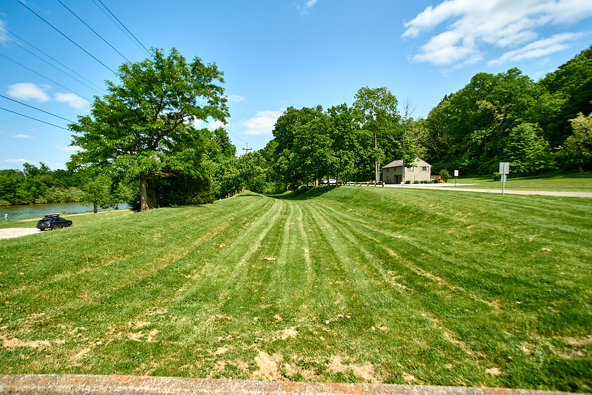
St. Bernard
 |
|
An open area with subtle grading marks the path of the canal and subway in St. Bernard.
|
Just north of Mitchell along the north and west edge of St. Johns German
Catholic Cemetery, the canal and subway right-of-way emerge from under
I-75. The entrance to Ludlow Park and the lower part of Phillips
Avenue in St. Bernard are on the infilled canal. At Vine Street,
an old concrete retaining wall that currently holds up the hillside
behind Wiedemann’s Brewery was built to hold back the canal waters from
the lower area around Wiedemann’s. The hill above was filled in
over time to expand the parking lot opposite Washington Avenue for what used to be Chili Time. A
bridge carried Vine Street over the canal, which turned sharply north at
the location of the municipal building. The parking lot and
service road heading to the north northeast is still an open area
marking where the canal ran. There was a bridge over the canal at
Ross Avenue, but this has since been graded with earth. City Park
Drive follows the canal back to I-75.
Norwood
Beyond St. Bernard, the canal continued north while the subway route
diverged to the east to follow the Norwood Lateral, OH-562. The
highway is on top of the right-of-way until Reading Road, where
the subway grading then ran behind the former Showcase Cinemas property, now
the Mercy Health Home Office and Corinthian Baptist Church. A
shallow cut approached the intersection of Ross and Section Avenues
where a short tunnel was located to the B&O Railroad at today’s
Joseph Sanker Boulevard crossing. No portals remain and it’s
unclear if any of the tunnels remain. The subway then ran at grade
next to the B&O until Harris Avenue where there was another short
tunnel under the now-demolished Zumbiel Packaging factory. The
tunnel emerged at the baseball diamond in Waterworks Park just east of
Forest Avenue, also the terminal location of the Cincinnati &
Columbus Traction Company. The portals have been concreted over
and are mostly buried on the park side, though they’re still
visible.
Elmwood Place & Carthage
Back to the canal. From the I-75 and Norwood Lateral interchange,
the canal ran either under or somewhat to the west of the highway.
It dipped down away from the highway around Murray Road, following
Prosser Avenue and the end of Silver Street in Elmwood Place to Township
Avenue. The right-of-way is currently being used for electrical
transmission towers. At Poplar Street a few blocks further north,
the canal also came to the west and ran behind the apartment buildings
on Hasler Lane. There’s an old electrical substation building on
Spruce Street that has a sunken loading dock next to where the canal
once ran. The canal then crossed 66th Street before veering back
east to I-75.
Hartwell & Lockland
Where I-75 crosses Mill Creek, the canal had another aqueduct. It
then ran next to the Big Four Railroad through the area of the Ronald
Reagan Cross-County Highway OH-126 and Galbraith Road exits. There
appears to still be grading for the canal in this area, but it’s not
readily accessible. The canal ducked under the Big Four where I-75
southbound and Mill Creek cross. It followed the highway north,
but there was a sharper turn to the northeast
that the highway smoothed out. Muscogee Street near the Cincinnati
and Lockland border is at an odd angle that follows the old canal
route. There was also the first lock north of downtown at this
location, Allen & James Service (?) lock #43. Where I-75 crosses the West Fork Mill Creek the canal
crossed on an aqueduct. Then through the heart of Lockland were
the three locks in quick succession between Wyoming Avenue and Patterson
Street: Flour Mill lock #42, Collector's lock #41, and Upper Lockland lock #40. All of this was obliterated by the I-75 trench which is
something of an historical artifact in its own right by now, having been
built in the early 1940s. North of Lockland the highway is mostly on
top of the canal right-of-way.
Evendale & Sharonville
At Glendale-Milford Road I-75 and the canal part ways. Evendale
Drive veers off to the northeast while the highway continues due north.
To the left of Evendale Drive is what appears to be a large drainage
ditch, but it’s the canal mostly intact, though with little to no
water. It’s now used for drainage, and Evendale Drive sits on a
much widened towpath. Grading for business driveways and parking
lots removed any obvious semblance of the canal prism, but the ditch
itself is unmistakable. Near Sharon Road where Evendale Drive
splits off and Canal Road starts, the canal itself is filled in.
It took a quick S-curve through the neighborhood at the end of Woodward
Lane before picking back up parallel to I-75 west of the large UPS
distribution facility. The canal from here to north of Kemper Road
is intact and usually has some water in it, though it’s
overgrown.
Crescentville & Rialto
Despite proximity to the sizable I-75 and I-275 interchange, there are
still remnants of the Crescentville/Sharonville aqueduct over
a Mill Creek tributary behind Dubois Chemicals at the end of Champion
Way. Both abutments are there, though the north abutment is somewhat
buried under dirt and debris. The south abutment is completely
intact and old rebar is hanging out of the broken remains of the trough
that once spanned the creek. The Crescent Paper Mill lock #39,
which was near
Crescentville Road is gone. However, the Rialto/Friend & Fox
Paper Mill lock #38 remains about 200 feet south of the intersection of
Rialto Road and Port Union-Rialto Road. It is on private property
however. Between here and Hamilton there’s actually a surprising
amount of canal that’s still intact. Much of it has some water
flow, though not nearly to the depth it originally had. An
overflow spillway and creek culvert remains about 600 feet east of the
Ellis Lake Wetlands trailhead at Firebird Drive off of Union Centre
Boulevard. There’s a walking and biking path that parallels the
canal through here. Many of the lakes and ponds were formerly ice
ponds from the canal era. Other remnants of culverts, spillways,
and ice pond diverters may be found in this area.
Hamilton
Little, if anything, remains of the canal in the built-up area of
Hamilton. It came into town along Ramona Lane near the Butler
County Regional Airport, then it ran under today’s Erie Boulevard along
the east side of town. Since this was over a half mile from the
center of town, Hamilton financed the construction of their own basin
that ran between High Street and Maple Avenue (formerly Canal Street)
all the way to 3rd Street. Construction started in the spring of
1828 and the basin opened March 10, 1829. The basin was 148 feet
wide at the water line to permit the turning of canal boats. Eventually
it was lined with wharves serving shops and warehouses. By 1877
the basin had fallen out of use and it was filled in and replaced with
numerous railroad tracks, some of which remain today.
On the northeast side of Hamilton where Greenwood Avenue becomes Canal
Road, the canal itself starts to become visible to the east side of the
road. This rural area north of Hamilton represents a sandwich of
19th century infrastructure. The Ford Canal hydraulic is to the
west of Canal Road, which was opened on January 27, 1845 to provide
water power for mills at the north end of Hamilton near 3rd and Black
Streets. The water is diverted from the Great Miami River at a dam
about 3.5 miles upriver near Rentschler Forest MetroPark. The
hydraulic provides 29 feet of fall and it spurred industrial development
of the northern part of Hamilton. By the 1910s it was mostly out
of use as factories had switched to coal-fired steam power. Henry
Ford purchased the hydraulic in 1918 and restored operation to provide
electricity to a new tractor factory. In 1963 after changing hands
a few times, the hydraulic was purchased by the City of Hamilton who
still operates a two megawatt hydroelectric generator at their 3rd
Street power plant. On the opposite side of Canal Road is the
Great Miami River Recreational Trail on the Miami & Erie Canal
towpath. The canal prism itself is visible here though there’s
little or no water in it. On the heelpath side, generally a bit
farther uphill, was the CH&D Railroad’s East Middletown
Branch. That section of the branch line was made redundant in 1927
when the Woodsdale cutoff was built from a new yard on the CH&D
mainline at New Miami. The cutoff provided a direct connection
from the blast furnaces in New Miami to Armco Steel in Middletown, and
it avoided congested tracks and sharp curves in the middle of Hamilton.
The old branch route was formally abandoned in 1934 save for about a
mile in Hamilton to the county fairgrounds that continued serving online
industries until 1972.
Rentschler Forest
 |
|
Remains of the Excello lock in the
present-day. Even though it was rebuilt in the first decade of the
20th century, it is still in rough shape.
|
Near where Canal Road does a two-point turn just west of Headgates Road
(named for the Ford Canal Hydraulic’s headgate/guard lock) there’s a
small stone structure in the canal bed that appears to be a water
management dam. There’s slots in the walls to allow wooden beams
to block the water flow, likely to serve ice ponds that were still in
use after the canal was abandoned. In Rentschler forest the canal
is plainly visible with some swampy plants in the bottom. Only
some broken concrete remains for a small culvert over Kennedy Creek just before it
flows into the Great Miami River. Next to it is a small
stone culvert under the park road (formerly the CH&D) and a larger
stone bridge for the walking path (a former roadway). Immediately
east of there is a small driveway and parking lot at the riverbank, and
there’s a sizable riprap overflow spillway for the canal. At the
east end of the park, Reigart Road sits on the heelpath and the old
railroad right-of-way. Where the road ends the recreational path
starts climbing up the hill away from the canal and railroad since the
Woodsdale cutoff comes in from across the Great Miami River shortly
thereafter.
Liberty Township & Excello
From this point north, the railroad continues to operate, mostly on the
heelpath of the canal. It’s rather inaccessible with few street
crossings. Concrete and stone rubble is all that's left of the
LeSourdsville/Gregory Creek aqueduct
in Monroe Bicentennial Commons (formerly LeSourdsville Lake Amusement
Park).
Approaching South Main Street in Excello, the canal and railroad part
ways to sandwich the property of the old Harding-Jones paper mill.
This mill operated from 1865 until 1990, and it was demolished in
2018. Newer flood walls behind the paper mill site mark the canal,
whereas the railroad runs through the front of the property. On
the other side of South Main Street is the Excello (or Excello Mills)
lock #34, which was the
first lock completed on the Miami & Erie Canal in 1826. The
lock itself is easily accessible and visible from the road, and the
spillway, where water was also diverted for use by Harding-Jones, was
cleared of brush and trees in early 2024 to make it more visible.
The lock was rebuilt with
concrete sometime between 1905 and 1911. A short distance away
there may be some remains of the aqueduct over Dick’s Creek near the
OH-4 and Oxford State Road exit, but that area is difficult to access
and the aqueduct was supposedly removed for road construction.
Just 300 feet north of OH-73, remains of the Amanda's Mill lock #33
forms part of the foundation for Cohen Recycling's Middletown facility
next to Verity Parkway.
Middletown
Verity Parkway marks the route of the canal through Middletown, except
for the four blocks between 2nd and Vail Avenues. Verity used to
run over the canal bed half a block to the west of today's Verity Parkway/Canal Road, but it was rerouted in the
mid-1970s as part of the City Centre Mart project. This was an
ill-fated downtown revitalization project that enclosed two blocks of
Central Avenue Broad Street to create a downtown
mall that retained many of the original buildings as tenant
spaces. Reconstruction of the streets and disruptions to traffic
flow put many of the already struggling stores out of business.
Verity Parkway was removed from the old canal bed and northbound traffic
was diverted to Clinton Street while southbound traffic was diverted to
Canal Street, eliminating a couple of very small oddly shaped
blocks. After high vacancy and increasing maintenance expense, the
mall's hallway structure was demolished, and the street grid was
restored in 2001/2002. The parking garage was demolished in
2010/2011. South of Reynolds Avenue is the Middletown Transit
Station, which sits in a large parking lot whose land was cleared for an
anchor store and additional parking garage that were never
built. The transit station sits at the former meeting point of the Miami & Erie Canal and the Warren County
Canal.
A small
canal memorial exists north of Central Avenue with historical
information and a fountain made to look like the canal with lock
gates. At the north side of town is the canal museum at Verity
Parkway and Tytus Avenue. The Middletown Hydraulic Canal sits on
the west side of Verity Parkway at that location as well. This was similar to the Ford
Canal in Hamilton and it was used exclusively for water power.
It's mostly intact but empty. The
two canals part ways at Hughes Street, but they come back together at
Access Road between Lowell and Bryant Streets. This was a busy
location where a feeder from the Great Miami River supplied water to
both the Miami & Erie and the Middletown Hydraulic. The dam in
the river was demolished in 1993. Dine’s lock #31 was also
located
here, buried by Verity Parkway, but the headgate structure for both
canals remains to the north of the road. The old feeder for the
Warren County Canal came off of
the next lock just a few hundred feet to the northeast along Tytus
Avenue, Lower Greenland lock #30, since the Warren
County Canal was 16 feet higher than the Miami & Erie with two locks
at downtown Middletown. There appears to be remnants of the Lower
Greenland lock buried in the front yard of the ODOT and Ohio BMV
facility at Tytus and Hawthorne. The canal ran along Tytus east of
Lowell, whereas Verity follows an alignment of the Ohio Electric/Cincinnati & Lake Erie. Beyond Middletown, Verity Parkway/OH-73 is
essentially over top of the canal.
Franklin
On approach to Franklin, the canal deviated from the highway to the
south to swing through the R Good Industries facility, formerly the
Franklin/Clutch's Paper Company, before curving
back towards Riley Boulevard. There are infilled remains of lock
#28, named Franklin/Clutch's Paper Mill,
just east of Dixie Highway. A few hundred feet to the north, a
shallow row of stones in the creek bed appears to be the only remains of
the triple-arch stone aqueduct over Clear Creek next to Riley
Boulevard. Through the rest of Franklin Riley is on the canal
bed. North of town where Riley merges
with Main Street, the canal remains to the east of the highway.
Franklin also had a separate hydraulic canal that came off the Great
Miami River opposite Chautauqua and opened in 1870. A sizable
headgate and concrete
channel remain at this location next to the recreational trail, and
much of the hydraulic is evident from Jackson Street and Atlas Roofing
to the headgate structure, though the hydraulic didn’t interface with
the Miami &
Erie. The Chautauqua Reservoir was drained when the dam was
removed in the 1980s or early 1990s. Just north of the dam
location near the south end of
Crains Run Nature Park is Sunfish lock #27 on the east side of
Dayton
Cincinnati Pike. It’s of similar concrete construction from the early 20th century as the
Excello lock. Two large culvert pipes took the
spillway water around the back side of the lock under an earlier
alignment of the Big Four Railroad.
Miamisburg
 |
|
An impressive overpass and viaduct carries the former Big Four Railroad over the Miami & Erie Canal south of Miamisburg.
|
South of Miamisburg is an imposing truss bridge and viaduct that carries
the former Big Four Railroad (now Norfolk Southern) over the remains of
the canal and Dayton Cincinnati Pike. After the devastating flood
of 1913, the Big Four bypassed their old route through Franklin by way
of Carlisle and two bridges over the Great Miami River. Due to the
shallow angle at which the new elevated railroad bridge crosses the
highway and the former canal, a sizable two-span skewed Pratt
through-truss bridge was built to span the highway. A viaduct made
up of several plate girder spans with small trusses was also built to
carry the railroad over the canal, which is dry but still very
evident. In fact, from this point all the way north to Miamisburg
Community Park, the canal prism is entirely intact, just drained of
water and planted with manicured grass. At the park the trench
ends, but the right-of-way continues along the east side of 1st Street
and no buildings sit on top of it, just parking lots and lawns.
There are a couple of old canal-era buildings that sit on the
heelpath side of the canal between Laurel and Central Avenues.
At the municipal building the canal started to veer slightly to
the east. Keelboat Park on Pearl Street has an old wall and
railing that is likely a culvert from when the canal was no longer
navigable but still used to convey water. A few blocks north of
there, Canal Street points the way to the location of the Sycamore Creek
aqueduct, which may have some remains.
North of here, the canal reappears as a shallow ditch following the east
side of Main Street and later Dixie Avenue. The recreational
trail is on a later right-of-way of the Ohio Electric/Cincinnati &
Lake Erie interurban, which relocated off of the highway in 1908.
On approach to West Carrollton at Riverside Auto Parts, the recreational
trail turns north to follow the Miamisburg & Carrollton
Hydraulic. This hydraulic canal was built in 1867 from a dam on
the Great Miami River near Miami Bend Park to provide extra water to the
Miami & Erie for industrial use in Miamisburg, mostly for paper
mills. It was reorganized as the Miamisburg Hydraulic Company in
1874. When the Miami & Erie Canal fell out of use, the
hydraulic company obtained permission from the state in 1920 to block
off the abandoned Miami & Erie Canal immediately north of where the
hydraulic feeder entered the main canal. They maintained the rest
of the Miami & Erie Canal south of this point to the aqueduct at
Sycamore Creek in Miamisburg, where several factories were
located. Around 1926, The Ohio Paper Company acquired all
outstanding stock of the Miamisburg Hydraulic Company. R.P.
Munger, a representative of The Ohio Paper Company, acted as President
from 1933 through at least 1955. That year, the company agreed to sell
an easement for $1.00 to the Miami Conservancy District so they could
build a levee on the land. This was most likely the end of the
hydraulic and this section of the Miami & Erie, though it remained
on maps well into the 1980s.
West Carrollton & Moraine
The canal took a straight shot through the center of West Carrollton
along the south side of Central Avenue. Little, if anything,
remains. Marina Drive in Miami-Erie Canal Park marks the route,
though there isn’t anything notable to see here either due to road
realignments and construction of the I-75 Dixie Drive exit. The
canal does reappear as a ditch to the east of Dryden Road just past Main
Street in Moraine, though much of it has been filled in. North of
the I-75 Dryden Road exit, the canal followed Arbor Boulevard, but
there doesn’t seem to be anything remaining.
Dayton
After crossing I-75 yet again, the canal right-of-way picks up along the
hillside at the south side of Carillon Park. Smith's Distillery
lock #17, which was originally located in Huber Heights, was dismantled
and reconstructed in the park along with a lock
tender/superintendent’s house. The canal continued along
this hillside until nearly South Main Street, where it turned sharply
north towards downtown Dayton. Power lines mark the Ohio Electric
Railway route which was on the uphill heelpath side of the canal.
Construction of the athletic fields and other facilities surrounding the
University of Dayton have wiped away any trace of the canal south of
Apple Street. North of Apple Street, Patterson Boulevard is on the
canal. Between 3rd Street and 2nd street a shelf of land to the
east of Patterson marks the canal, and the land drops off several feet
to the east. Between 2nd and Monument there are shallow
reconstructed sections of canal on the east side of the street. At
Monument, the canal turned to the northeast to run along Water Street
and through barren industrial land towards the Mad River. The
south abutment of the Mad River aqueduct remains along the recreational
trail near the end of Ottawa Street. This aqueduct, which was a
wooden 3-hinged arch sitting on stone piers, similar to the Great Miami
River and Dry Fork Creek aqueducts on the Cincinnati & Whitewater
Canal, was destroyed in the 1913 flood, and only the ruins of the south
abutment remain.
Beyond Dayton
Generally speaking the canal continued to follow the east side of the
Great Miami River until I-70. There are some canal locks and small
parks marking points of interest. At the Taylorsville dam, the
canal crossed the river on a large aqueduct and embankment. The
earthworks remain, as does part of the aqueduct's western abutment. A recreational trail follows the canal most of
the way to Troy, with locks accessible nearby, especially in Tipp
City. North of Troy the canal was basically smashed between County
Road 25A and the Great Miami River. It ran through the middle of
Piqua between Main and Spring Streets where a large alley/parking area
marks the spot. Johnston Farm north of Piqua has a canal boat in a
short section of intact canal up to the next lock about a mile
upstream at Loramie Creek. Lockington is just another mile farther
north, where the five locks in a row remain (the aqueduct over the
Great Miami River and the sixth lock are out of reach). Some parts
of the Sydney feeder remain east of here as well.
Past Lockington the canal runs through open country, much of it with
at least some water in it. North of Fort Loramie it is actually
very evident with a fair amount of water flowing, just not at full
depth. It is completely intact and maintained through the
heart of Minster, though street crossings make it un-navigable.
Between Minster and New Bremen it is overgrown and stagnant, but mostly
full of water. New Bremen has intact and full sections, including a
restored lock. North of New Bremen the canal is treated as mainly
a drainage ditch. St. Marys has intact canal through all but one
block of town, including remains of the aqueduct over the St. Marys
River. The wooden aqueduct trough collapsed in 1943, and it was
rebuilt with steel beams and pipes to maintain water flow, while original
spillways to the river remain at each side. A
restored lock and a canal boat sit in the canal between Spring and High
Streets. North of town
the wider cross section of the canal is readily apparent as compared to
farther south. It continues to run intact and full of water
several miles north with a couple more locks along the way. At
Sixmile Creek is a notable aqueduct that is still functional. It’s
unique in being a multi-level stone and concrete aqueduct and spillway
with an integrated towpath bridge.
The canal continues fully intact through Spencerville but it gradually
becomes overgrown and dry until Delphos where it is intact and full of
water except for one block in the middle of town. North of town
the canal is little more than a shallow depression in the ground with
little to indicate its history. This continues through Ottoville,
Melrose, and Junction where the Miami & Erie met up with the Wabash
& Erie Canal. North of Junction the situation is much the same
to Defiance. The route into Defiance is clear but dry. One
of several locks that lowered the canal into the Maumee River remains as
part of an amphitheater at 3rd and Perry. The canal then ran in
slackwater until Independence Dam where the canal channel remains on the
north bank of the Maumee River. The canal continued this way past
Napoleon until 1.5 miles west of Grand Rapids where it dumped back into
the Maumee River. At Providence Dam opposite Grand Rapids, the
canal split off the river again, and there are numerous mills, locks,
and a museum. From here to Waterville a recreational path follows
the canal which is in various states of fill. Anthony Wayne Trail
sits atop the canal through Maumee to Toledo. The canal ended in
what is today a dowdy industrial neighborhood southwest of downtown
Toledo underneath the I-75 Anthony Wayne Trail interchange at
Collingwood Boulevard. It emptied into Swan Creek which provided a
route to the Maumee River, Lake Erie, and beyond.
Photos from Downtown Cincinnati to Downtown Dayton
Photos of the Subway in Bond Hill & Norwood
Return to Index