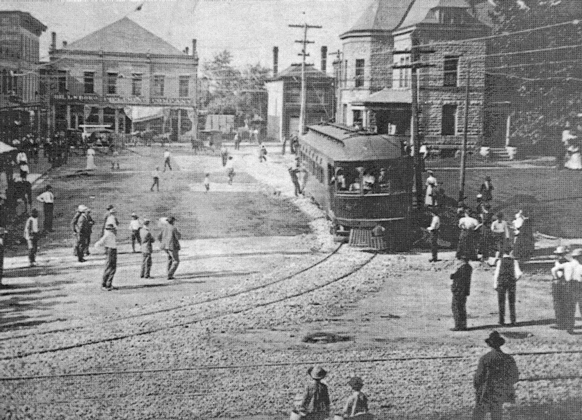
The first C&C car around the courthouse in Hillsboro on July 27, 1907. From "Cincinnati and Columbus Traction Co." by David McNeil, original photo by Frank Pence, from the Walter Simpson collection.
C&C - Cincinnati & Columbus Traction Company
(Hillsboro Short Line, Swing Line)
Norwood - Hillsboro
1906-1920
Standard Gauge
Constructed by the Cincinnati & Columbus Traction Co., 1905-1907
Abandoned east of Owensville, 1919
Abandoned completely, 1920
This was a standard-gauge interurban, 53 miles long, between Norwood, at the edge of Cincinnati, and Hillsboro. It was chartered in 1901 and opened on April 22, 1906. It was promoted locally and early in its history was known as "The Swing Line," after its principal promoter. The company's ambition to build east to Chillicothe or Columbus were never realized. It paralleled no railroad, although the Baltimore & Ohio had a branch into Hillsboro. The company was never profitable enough to pay a dividend. The property was so badly damaged in the flood of 1913 (which injured all the lines in the area) that the company applied for voluntary receivership, from which it never emerged. In common with most interurbans, it had a very bad year in 1918, when it lost $21,036. The receiver concluded the property was hopeless and in 1919 applied for abandonment. Permission was granted, but an unsuccessful effort on the part of local residents to refinance the road and to continue it in service delayed sale for scrap until 1920. Its power business outlasted the rail operation, but was also sold to local interests in 1920. Its cars, heavy Jewett combines, were sold to the THI&E, the Joplin and Pittsburgh, and the Northeast Oklahoma, which was about to electrify. (From: Hilton, George W. and John F. Due, The Electric Interurban Railways in America. Stanford University Press, 1960)
|
The first C&C car around the courthouse in Hillsboro on July 27, 1907. From "Cincinnati and Columbus Traction Co." by David McNeil, original photo by Frank Pence, from the Walter Simpson collection. |
Despite never making it to its intended destination, the Cincinnati & Columbus was still one of the longest of the Cincinnati interurban lines, not counting the C&LE which was pieced together from a handful of previously independent roads. Despite its length though, this was Cincinnati's shortest-lived and one of the weakest interurbans. Ridership in 1912 was only 608,000 people, higher only than the two very weak IR&T lines to Bethel and New Richmond, which had to compete with CG&P and a mostly undeveloped river floodplain respectively. Negotiations for franchises and procurement of right-of-way began in 1901 by the Swing family, though construction didn't finally start until January 1905. Inspection trips over the road east of Milford were conducted in August and September of that same year, and regular operations between Milford and Hillsboro commenced on October 1, 1905. Bridge worker strikes delayed opening the line west of Milford, and the Norfolk & Western was denying the C&C the right to cross their tracks west of Hillsboro, though tracks to Elm and Main streets were already in place (it's interesting to note that the C&C was also a customer of N&W, who supplied coal to the power house in Perintown). Once the Little Miami River bridge was completed, the whole line was open to regular traffic in April of 1906. A short extension from Main and Elm to a loop around the courthouse in Hillsboro was opened on July 27, 1907, completing the full extent of the route.
During the early negotiations, this interurban fought with the CM&L over the bridge crossing the Little Miami River in Milford. The C&C couldn't get a franchise, and had to build its own bridge to the south. The destruction and replacement of this bridge in a 1907 flood showed how big of a liability it was to the company. They replaced the destroyed span with a second-hand truss from the CH&D. The bridge was washed away again in the1913 flood, and this (among other damage) sent the C&C into receivership. It limped along for a few more years but by 1918 the writing was on the wall. Unlike other nearby interurbans like the CM&L or the CG&P, they made no attempt to reorganize, buy new equipment, or generally upgrade their facilities. There was no prospect for improved ridership, so rather than doubling down they decided to simply give up. Had they decided to modernise, the C&C might have lasted into the mid or possibly late 1920s at best, as that's when other Cincinnati interurbans that did modernize began to fall apart anyway.
There was pressure from the citizens of Madisonville, Madeira, and Ramona (a small community at Drake and Shawnee Run Road in Indian Hill) to keep the line, because it was a fast way to get to the factories in Norwood where many residents worked. Since most of the streetcar lines ran radially from downtown, taking the street railway would involve going to Walnut Hills and back out. That would take some 45 minutes, instead of 10 on the C&C. Unfortunately, the Cincinnati Street Railway had no interest in that, and residents were left to fend for themselves. The people of Hillsboro were the most invested in preserving operations, since the N&W and B&O branches to their town provided horribly inadequate service, generally just one shuttle each way to Sardinia or Blanchester per day. Nonetheless, on October 25, 1919 the last car ran on the outer 30 miles of the C&C between Owensville and Hillsboro. Talks of combining the C&C and CM&B and abandoning portions of each never materialized. The line was sold for scrap on January 31, 1920, and wrecking crews began dismantling it in March. The power plant, which provided electricity to Madeira, Perintown, Owensville, Monterey, Marathon, Fayetteville, and the Madisonville lines of the street railway, stayed in service through April when the Union Gas and Electric Company took over the power lines and hooked it up to their system.
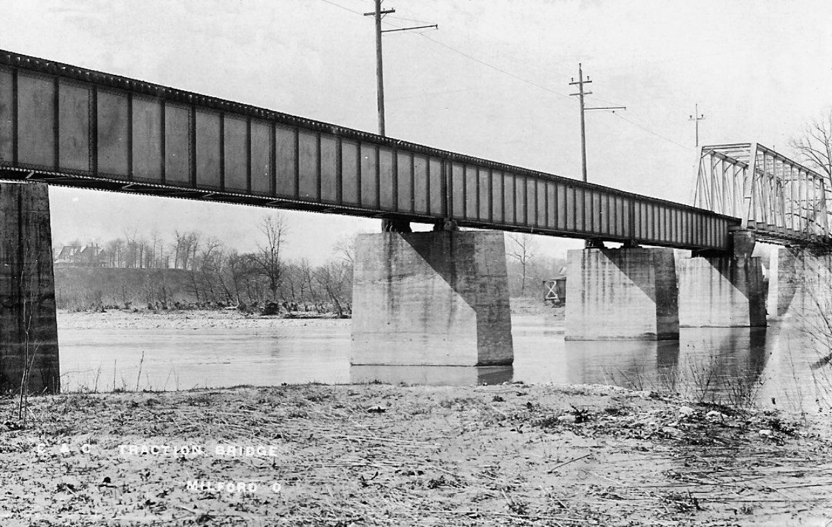 |
C&C bridge over the Little Miami River at Milford, a perpetual sore point and expense for the company. |
Despite the length of the road, the C&C was handicapped by its standard gauge track and remote terminal location in Norwood. It benefited very little from suburban traffic, since it traveled through areas near Cincinnati that are sparsely populated even today. Also, the hilltop soil in Clermont, Brown, and Highland Counties is not well suited to intensive agriculture, so bulk shipments of commodities like corn or grains was limited, and overall the area of southern and southeast Ohio has been in a general state of decline, or at best stagnation, for over 100 years. Canned fruit and milk shipments were a staple of the C&C's freight hauling, but it paled in comparison to what it could have been in a more healthy farming and industrial locale like the Great Miami Valley.
Weaknesses aside, the C&C was one of the better
surveyed and constructed interurbans in the area. Aside from street
running in Norwood and Madisonville, it managed to stay on its own
right-of-way off to the side of the streets for most of its length. Once
past Milford it generally operated to the side of the roads while
detouring a block or so away from US-50 at most towns. While grades were
somewhat steep within the Cincinnati city limits, it took a fairly
curvy route through the various hills and valleys to keep the grades
manageable. Utilization of the never completed narrow gauge Cincinnati & Fayetteville
right-of-way from Vera Cruz to Fayetteville, as well as a very short
stretch through the heart of Milford, kept grades manageable across
country as well. Stone culverts in Madeira and Indian Hill were
meticulously constructed and some remain completely intact and
functional today after more than 100 years. Such over-engineering did little to help the finances of the company.
The route's terminal was at the end of streetcar route 5 in Norwood on Harris Avenue where there was a small wooden station building and a siding for transferring freight to and from the CL&N. Since this was a standard gauge line, passengers had to transfer to streetcars here, or take a steam train to downtown via either the B&O or the CL&N. With the proposed subway running directly behind the old station location, this area would have been one of the busiest intermodal transfer points in the area, with the streetcar line, C&C, subway, and two railroad lines all intersecting nearly on top of each other. Harris Avenue is now right at the edge of the Norwood Lateral highway, and with the subway never being finished, the CL&N dismantled south of the B&O, and no C&C or streetcars left, the area is a bit of an empty wasteland now. East of the station, the single track line went down the center of Harris and quickly struck out on its own right-of-way upon reaching Poplar Street. The crossing of the C&C marked the east end of Norwood Avenue until after it was abandoned, and the road currently narrows noticeably just east of Poplar. The houses on the north side of the street are basically on top of the old roadbed. The road descended into the Duck Creek valley, at the present location of the I-71/Norwood Lateral interchange, just east of the Pennsy's connecting track and Norwood station that was built after the C&C was torn up. All traces of the C&C and Duck Creek Road were obliterated by construction of I-71, and the creek itself has been channelized through much of this area. It is very hard to find anything left of the C&C around here because of this.
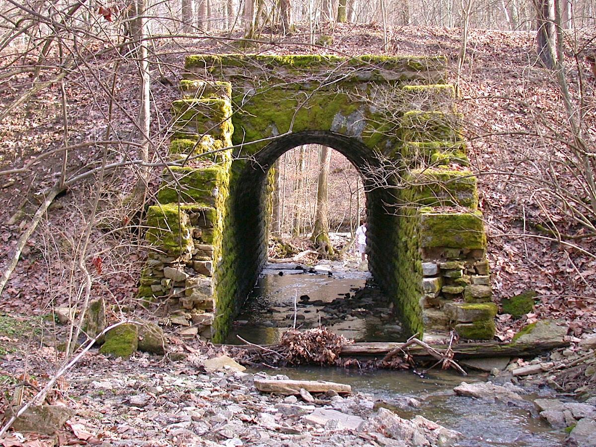 |
One of the many beautifully constructed stone culverts in Redbird Hollow in Indian Hill. |
Past Ridge Avenue the route ran some 20-30 feet north of Duck Creek Road to just west of today's Oaklawn Drive, a newer road built in the 1960s, where it turned southeast towards Madison Road. Since all the development along Duck Creek, Oaklawn, and the subdivisions around Collinwood Place and Eastwood Drive happened after the C&C was abandoned, the only remaining trace is about 100' of graded right-of-way in a ravine behind the end of Collinwood. The route then followed Madison Road to Whetsel Street, north to Chandler Street, and finally to a private right-of-way west of, and higher up the hill than the B&O outside the city limits. There are many stone culverts and a lot of grading along this stretch of hillside. The route crossed the B&O on a small bridge just west of downtown Madeira. On the east side of Miami Avenue, the original substation remains, having been recently renovated. This was a combined passenger and freight station that also housed the first electrical substation between Cincinnati and Hillsboro. The rails then crossed Camargo and went through Sellman Park where there was once a wooden trestle over a creek. The road went through what would later become cookie-cutter suburban development in Indian Hill to the site of the current village hall, formerly the neighborhood of Ramona. The line ran to the south behind the elementary school then descended into a valley, called Redbird Hollow, and followed this almost all the way to Given Road. The right-of-way through Redbird Hollow is very beautiful, and it's a popular walking trail with several bridge structures to see. The best way to get there is to park on the east side, where there's a small gravel parking lot on the side of Given Road. It takes about 40 minutes to walk the entire length of the trail, which almost reaches Shawnee Run Road, but disappears before reaching the school play fields. East of Redbird Hollow, the C&C ran right along the southern border of Indian Hill where there are some bridge abutments visible from Given Road. It then went into Terrace Park and then briefly across Wooster Pike. It crossed the CM&L on Wooster and another small creek (the same one as in Redbird Hollow, actually) just past the PRR/Little Miami Railroad overpass and then crossed the Little Miami River into Milford. There are several piers for this bridge remaining, although they are not accessible from any roads.
Upon reaching High Street in Milford, the C&C ran on the graded right-of-way of the never-completed narrow gauge Cincinnati & Fayetteville Railroad which was started in 1877. It was going to connect with the Cincinnati & Eastern (later Norfolk & Western)
line in South Milford along Roundbottom Road. The C&C was able to
use the graded roadbed around the hill to approximately the intersection
of US-50 and OH-28. There's an alley behind some of the houses along
Main Street in Milford that marks the route, but after that the
commercial development and road widening has obliterated any remains
until well past I-275. The carbarn was located south of US-50 near
Mohawk Trail but it burned down in 1959. The power plant was not
directly on the line, but on the west side of Binning Road in Perintown
so coal could be dumped from the adjacent N&W railroad and it could
pump water from the East Fork Little Miami River.
Beyond Perintown, there are several areas where the route is easily
viewed. At Dry Run Road there's bridge abutments next to US-50 at
Dry Run Creek. In Stonelick, just east of the OH-222
intersection, the C&C veered off the highway to take a more gradual
climb up the hill to Owensville. The grading can be seen gradually
curving away to the south just before the road starts climbing.
There are several cuts and fills between US-50 and Possum Hollow Road,
but they are mostly inaccessible on private property. The wooded
part of McKay Road is on the right-of-way. The unused roadbed can
be seen when going back towards US-50 and facing northeast. The
road turns left and goes uphill, while the right-of-way follows a more
gentle curve into private property, ultimately forming the western shore
of Owensville Lake. Carey Lane, a private road, was the C&C,
and a small land bridge across the lake marks the roadbed, after which
point the rails came back to US-50.
West of Owensville, the C&C turned north off the highway to run on Walnut
Street. It then headed northeast towards Broadway and Apgar,
crossing right through today's location of St. Louis School.
Behind the school and cemetery there's a noticeable cut approaching a
tributary of Stonelick Creek. The tracks then took a long tangent
before snugging back up to US-50 near Patterson Run at Glancy
Road. The tracks stayed somewhat off to the north side of the
highway until Hutchinson Road when they started to diverge again on
approach to Monterey. Due to the flat terrain there's not much to
see there, and the tracks came back to US-50 at OH-133. The tracks
then ran with the highway to Marathon where they turned northeast at
the small creek next to North Street. The old substation building
was at North and Fomorin, but it burned in 2010. The right-of-way
forms the southeast boundary of Marathon Park before striking out across
country. It crossed Township Highway 100 about 300' south of
Woodland Drive S and aerial views show evidence of grading in the woods.
Approaching Lake Lorelei and OH-131, the C&C was on a shallow bench
cut on the side of a gentle hill. About 500' west of the entrance
to Lake Lorelei there's a small barn and a farm pond. The pond's
dam was the C&C, and while the grading does cross the road, it's
barely perceptible, and it disappears as the entrance to Lake Lorelei
was regraded. The C&C crossed the entrance road and Glady Run
about 100' north of OH-131 where it also picked up the right-of-way of
the Cincinnati & Fayetteville Railroad. The right-of-way then
heads northeast, crossing Vera Cruz Road and Victory Lane with little
fanfare. The tracks then crossed US-50 at a very shallow angle,
and this is somewhat visible as a few buildings and fence lines follow
the route. The C&C then turned gradually east to cross East
Fork, running south of town below Lynch Street and along the north
property boundary of Fayetteville Perry Middle/High School. The
station was roughly where current US-68 crosses. The tracks came
back to US-50 east of town near the Perry Township Community Center, and
they stayed with the highway until Dodsonville.
At the gas station west of Dodsonville it's clear where the C&C
started to split away from the highway to the south, as power lines
follow still the railroad and not the highway. There doesn't appear to
be anything notable where it crossed OH-134 or Dawson Road. Beyond
Dodsonville the tracks stayed with the highway, although the highway
was realigned a half mile east of town, leaving the old alignment
orphaned on private property. The C&C passed straight through
Allensburg without detouring. At Hoagland however, the B&O
branch to Hillsboro came in from the northwest and crossed US-50.
The C&C also diverged to the south to avoid crossing the railroad,
and they ran next to each other for the next 2.5 miles to the Hillsboro
city limits. Here, the N&W branch to Hillsboro came in from
the south, a good 1.5 miles from the center of town, hence why obtaining
permission to cross the N&W was so important. All three
railroads ran northeast to Willettsville Pike, crossing near Moore Road
and curving back towards the south. The C&C took a slight
detour through the woods to reach Elm Street, which it then followed to
Main, then High, then Trimble, and Foraker, looping counterclockwise around the
courthouse.
Photographs from Norwood to Hillsboro